Travel

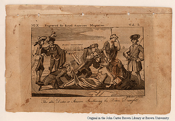
John Carter Brown Library Treasures | Photographs

View a collection of some of the treasures from the John Carter Brown Library on the Brown University Green in Providence, Rhode Island.

An old illustration depicts several men, including one with a sword, attending to a seated figure being held by another man. A man in a military uniform stands on the right. Text at bottom reads: "The able Doctor, or America Swallowing the Bitter Draught.

Coffee By Design | Portland, Maine

Photo Credit : Katherine Keenan
View some of the John Carter Brown Library’s most treasured collections.
A Venetian map of North and South America published c. 1597. It took centuries for Europeans to create an accurate picture of the lands they were discovering. Note that in this map, Australia appears to be connected to Antarctica
An English map of New England published c. 1697
An English map of New England published c. 1720. Note that in this map, the coast of Maine extends at an almost 90 degree angle starting at the Piscataqua River.
An English map of New England published c. 1755. In this image, the region looks almost as we know it now, with the notable exception that New Hampshire extends across all of Vermont and most of Maine
A city plan of "Ye Great Town of Boston" in 1733. The text in the lower left corner gives the founding dates of the city's churches, the dates of the major fires, and dates of its small pox epidemics
A city plan of “Ye Great Town of Boston” in 1733. The text in the lower left corner gives the founding dates of the city’s churches, the dates of the major fires, and dates of its small pox epidemics
An image of Boston with war ships in its harbor. This was published in 1774, just before the Revolution
The title page of an Algonquin language bible, printed in Cambridge in 1663
A political cartoon published in 1774 lampooning Britain's response to the Boston Tea Party. In this image, the American colonies are depicted as an Indian woman having tea forced down her throat
A political cartoon published in 1774 lampooning Britain’s response to the Boston Tea Party. In this image, the American colonies are depicted as an Indian woman having tea forced down her throat

Justin Shatwell

More by Justin Shatwell

Leave a Reply

Your email address will not be published. Required fields are marked *

Login to post a comment