


The Encyclopedia of Fall: M is for Mohawk Trail
Photo Credit: Library of Congress The fast way to reach the Berkshires from the east is to hop on the Massachusetts Turnpike (I-90) and set your cruise control to 65, or 70 if you want to test the five-miles-over rule. Or you can drive through history–slowly, windows open, stopping here and there, taking photos, drinking […]

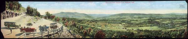 Photo Credit: Library of Congress
The fast way to reach the Berkshires from the east is to hop on the Massachusetts Turnpike (I-90) and set your cruise control to 65, or 70 if you want to test the five-miles-over rule. Or you can drive through history–slowly, windows open, stopping here and there, taking photos, drinking in the mountain views that have drawn people for nearly a century. The Mohawk Trail comes with a more pedestrian name: It’s part of Route 2, from Orange to Williamstown, a delicious 65 miles or so of tourist traps, curves, rises, declines, and one hold-your-breath hairpin turn above the Hoosic Valley that’s an attraction in its own right. If this were an amusement park, you’d pay for the chance to steer around and around it. The first commercial foliage tours wended their way along this road. They were onto something special, and the road rarely lets you down.
Photo Credit: Library of Congress
The fast way to reach the Berkshires from the east is to hop on the Massachusetts Turnpike (I-90) and set your cruise control to 65, or 70 if you want to test the five-miles-over rule. Or you can drive through history–slowly, windows open, stopping here and there, taking photos, drinking in the mountain views that have drawn people for nearly a century. The Mohawk Trail comes with a more pedestrian name: It’s part of Route 2, from Orange to Williamstown, a delicious 65 miles or so of tourist traps, curves, rises, declines, and one hold-your-breath hairpin turn above the Hoosic Valley that’s an attraction in its own right. If this were an amusement park, you’d pay for the chance to steer around and around it. The first commercial foliage tours wended their way along this road. They were onto something special, and the road rarely lets you down.
Mel Allen
Mel Allen is the fifth editor of Yankee Magazine since its beginning in 1935. His first byline in Yankee appeared in 1977 and he joined the staff in 1979 as a senior editor. Eventually he became executive editor and in the summer of 2006 became editor. During his career he has edited and written for every section of the magazine, including home, food, and travel, while his pursuit of long form story telling has always been vital to his mission as well. He has raced a sled dog team, crawled into the dens of black bears, fished with the legendary Ted Williams, profiled astronaut Alan Shephard, and stood beneath a battleship before it was launched. He also once helped author Stephen King round up his pigs for market, but that story is for another day. Mel taught fourth grade in Maine for three years and believes that his education as a writer began when he had to hold the attention of 29 children through months of Maine winters. He learned you had to grab their attention and hold it. After 12 years teaching magazine writing at the University of Massachusetts-Amherst, he now teaches in the MFA creative nonfiction program at Bay Path University in Longmeadow, Massachusetts. Like all editors, his greatest joy is finding new talent and bringing their work to light.
More by Mel Allen